

In mid-October, I did a solo road trip to photograph the fall leaves in Virginia and North Carolina. This trip was inspired by a story I wrote for the Washington Post about how to travel safely and ethically to national parks. Normally, I’m already in Asia by the fall so I always miss the leaves so it was exciting to get to see them. In this post, I share some of my photographs, logistics and travel tips for this region. I also have a section focused on travel safety where I dig into my safety protocol. [Please note COVID rates were much lower than current levels when I did this trip and both states had mask mandates. Cases have more than doubled since then so I would not do this trip now.]
Free Apps to Help With Planning
Both the Blue Ridge Parkway and Shenandoah National Park have free apps that help with planning. Bathrooms are few and far between so these apps were really helpful. Download both and offline maps (Maps.me is good for hiking trails!) beforehand since service is spotty in both locations.
How to Predict When The Leaves Change
There are a lot of factors that determine when the leaves start to change color ranging from elevation to weather. Shenandoah National Park usually peaks about the second or third week of October. They have a YouTube channel where they release a new video every Thursday at 2 p.m. with updates, which is how I determined my trip dates. The leaves probably peaked a few days before I arrived (over the weekend), but I only wanted to travel during the week to avoid crowds. (I also called visitor centers to ask about the status of leaves to help with planning.) The higher elevations of the Blue Ridge Parkway like Boone and Grandfather Mountain probably peaked about five days or so before I arrived but were still beautiful. You can’t visit multiple elevations on the same trip and expect the leaves to all be peak at the same time. Overall, my trip was beautiful even if I missed the peak in a few areas.
My Five-Day Road Trip Itinerary
Day 1: Shenandoah National Park (Central)
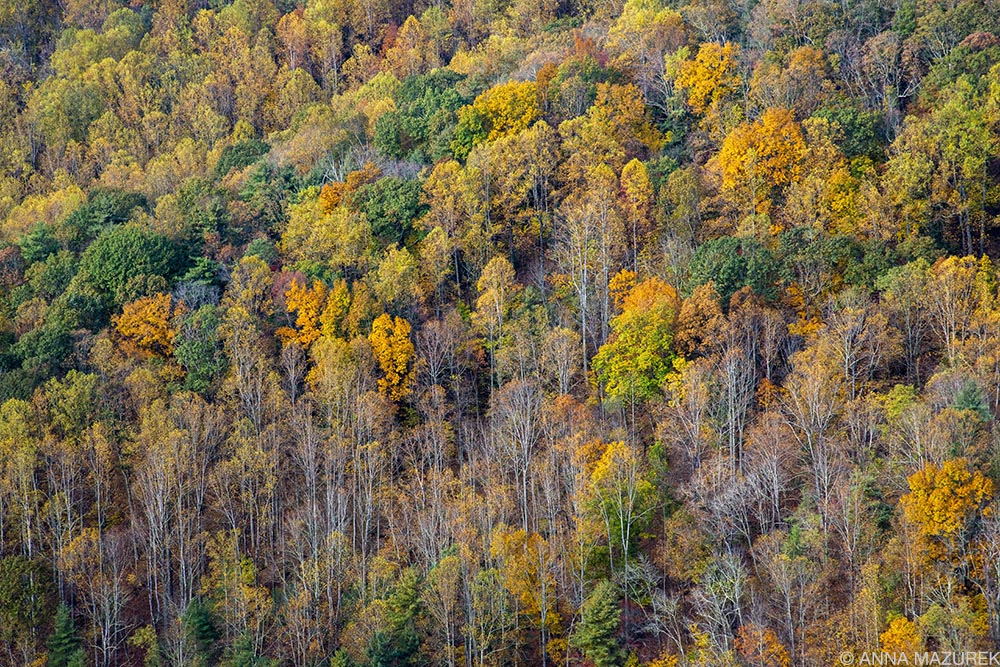
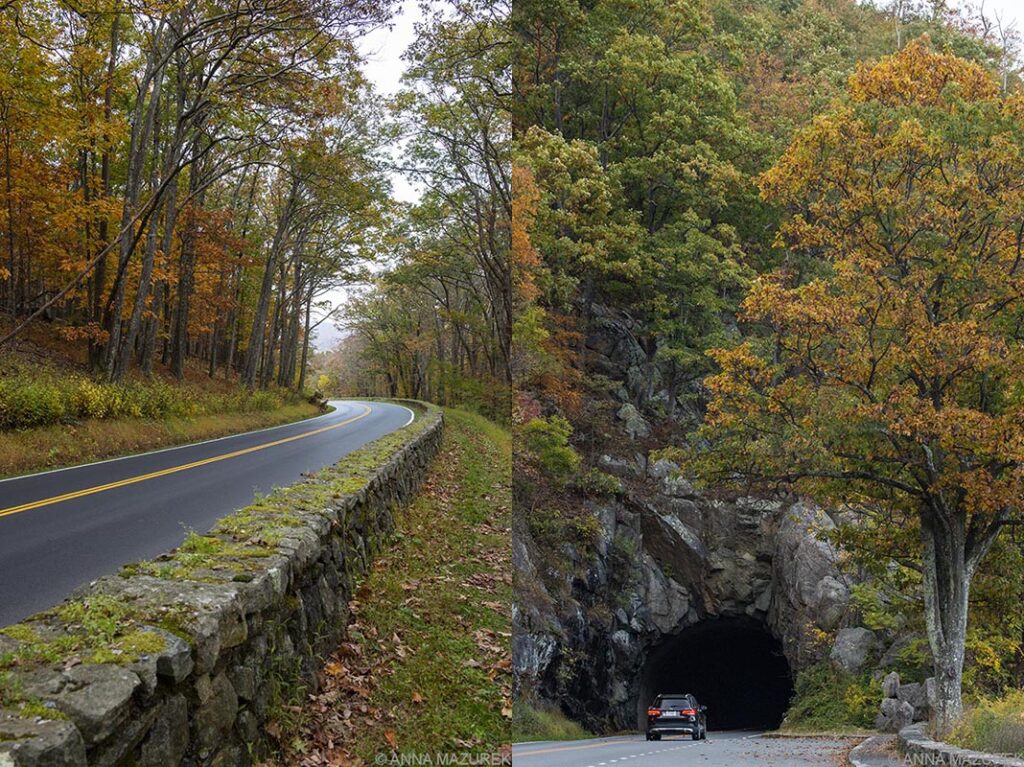
To avoid crowds, I traveled during the week (Monday to Friday) for this five day trip. I started my trip from South Carolina and drove 6.5 hours up to Harrisonburg, Virginia where I stayed the first two nights. I got to the park around 3 p.m. at the Swift Run Gap entrance station then drove north to the Thornton Gap entrance station on Skyline Drive, the main scenic road that runs 105.5 miles through the entire park. This part of the park is the most crowded since it’s closer to the big cities of Baltimore and Washington D.C. I avoided popular spots like the Dark Hollow Falls Trail (the parking lot was overflowing). I drove about half a mile, and the scenery was stunning on a series of curves lined by a rock fence. I turned around went back and parked along the side of the road. There was a path by the side of the rock wall away from traffic. The view was stunning of Skyline Drive and the trees! I literally had the place to myself and only passed three people on the trail. The entire park is beautiful so I learned to skip the busy spots and stop at the deserted ones! This trail along with the tunnel near the Thornton Gap Entrance were my favorite spots to stop.
Day 2: Shenandoah National Park (South)
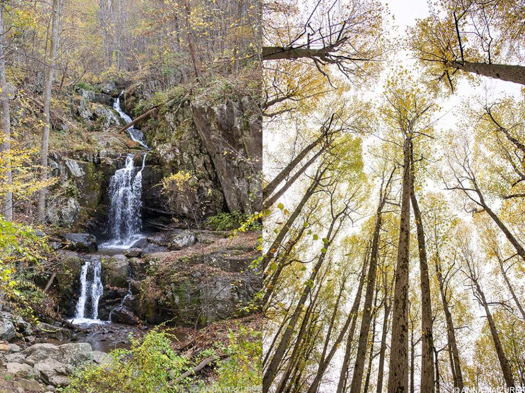
The southern portion of the park is the least crowded since there’s no accommodation options except one campground. I got up at sunrise to hike the Doyle’s River Falls Trail (3 miles). There were only five cars in the parking lot when I arrived to start the hike at 8:30 a.m. and 20 cars in the lot when I finished around 10:30. (I stopped a lot for photos, which is why it took me so long.) I had the trail to myself the entire way to the falls—it was glorious! The leaves were STUNNING. The trail was downhill the entire way to the falls and a 1,189 foot elevation gain on the way out. There are two viewpoints for the upper and lower falls, which is where I turned around. (The trail continues to Jones Run Falls, which his another waterfall.) When I left the falls to hike out, I started to pass other people. The trail was wide so it was easy to socially distance but I still put on a mask when I passed others, which is what the park service recommends. Only a fourth of the people I passed did the same. Overall, I felt safe.
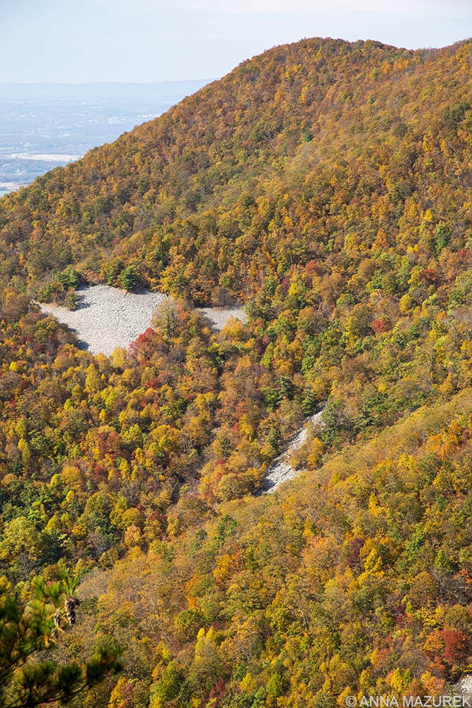
My next stop was Black Rock Summit, a short one-mile loop facing the west with a rock outcrop at the end of the trail. There were more people on this trail at the viewpoints at the end, but there was plenty of space to distance myself. The trail back to the parking lot was different that the one you take out so that made it really easy to avoid people. The view was really nice , and the rocks made for great scenery for photos.
My next and final hike of the day was Turk Mountain (2.2 miles). The trail was very narrow and steep, which made it feel a lot more crowded than it actually was. This was the only trail I didn’t feel safe on because it was hard to socially distance. (It’s a totally safe trail to hike in non-COVID times.) The end of the trail was a bunch of large steep rocks with a western facing view. It was beautiful but again, not the safest to distance during COVID. You needed both hands to climb the rocks at the end so take hand sanitizer if you do this trail! I spent the rest of the day driving Skyline Drive and stopping at viewpoints. Honestly, the leaves were so lovely that I just enjoyed driving! I went back to Harrisonburg again for the night.
Day 3: Blue Ridge Parkway – Afton to Fancy Gap
(Milepost 0 to 199)
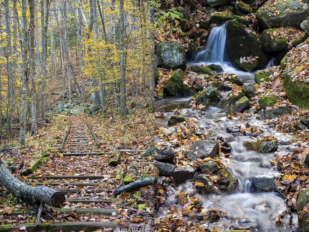
The Blue Ridge Parkway covers 469 miles through 29 counties in North Carolina and Virginia. The parkway begins at the end of Skyline Drive at the southern edge of Shenandoah National Park. The parkway attractions are labeled by mileposts, which is what I’ll use to lable my favorite stops. I had a lot of ground to cover so I couldn’t stop to do any long hikes. I wanted to stop at Humpback Rocks (MP 5-8) but didn’t have time to do the hike, which looked pretty crowded based on the parking lot. My first stop was one of my favorites of the entire trip—Yankee Horse Ridge and Wigwam Falls (MP 34.4). The waterfall was small but gorgeous. There is also a small set of reconstructed logging railroad tracks that once covered 50 miles of this area in the early 1900s. The leaves were stunning here. It’s a very small stop right of the side of the road. I had the place to myself for the first 30 minutes. I stayed here for ages taking photos. I even got out my tripod to do a long exposure of the waterfall!
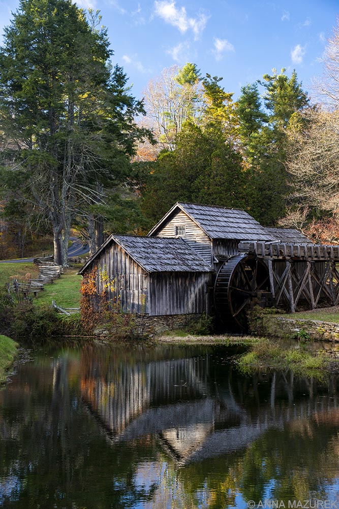
I stopped briefly at the Peaks of Otter area, which was gorgeous but a bit crowded. I considered doing the short one-mile loop around Abbott Lake but decided to just hit the road so I could stop in Roanoke for lunch. (I highly recommend Mac & Bobs, a great local spot!) Part of the parkway was closed near Roanoke so I had to take a short detour. I had a lot of ground to cover so I didn’t stop for any long breaks until I got to my final destination and one of the main places I wanted to photograph—Mabry Mill (MP 176). The gristmill was built around 1905 by Ed and Lizzie Mabry who later built a sawmill and blacksmith shop, which were all acquired by National Park Service in 1938. There is a restaurant named after the mill by the parking lot and the buildings are open for exhibits. My goal was to photograph the mill, but I wasn’t sure if the light would be best in the morning or at sunset. Now, I can officially say the best time to photograph Mabry Mill is an hour before sunset when the light hits the mill just enough so it reflected in the pond with the blue sky overhead. The restaurant was closed, but there were still a good amount of people around but enough space that I felt safe. I wore my mask the entire time and was shocked by how many people were standing closely and talking to strangers with NO masks. They were taking photos of each other with their phones! (Once upon a time, I worked at the Apple Store so I know how gross phones are so there’s no way I’m touching a strangers phone to take a photo during COVID!) To be clear, Virginia and North Carolina both have statewide mask mandates in place for public areas. I stayed in Hillsville, Virginia for the night.
Day 4: Blue Ridge Parkway – Fancy Gap to Blowing Rock
(Milepost 199 to 293)
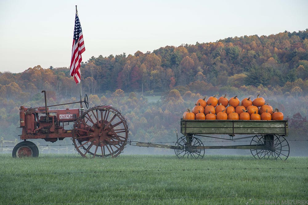
Since I’d gotten the photo I wanted of Mabry Mill the day before, I hit the road early. Shortly after I got on the parkway, I passed a farm with an old red tractor with an American flag parked in the field with a trailer filled with pumpkins (photo above!). It was one of the most Americana images I’ve ever seen. I did a quick U-turn and went back to shoot it. The fog was still lingering, and the colorful trees in the background were perfect. The road was lower than the field so I had to shoot through the fence using my aperture to blur the barbed wire, which you can just barely see in the photo.
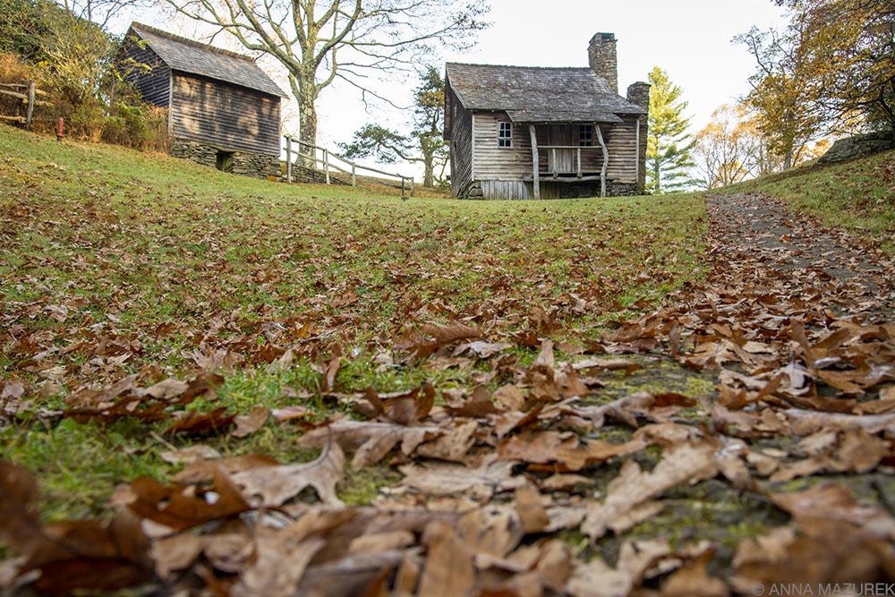
My next stop was Doughton Park (MP 238) to see Brinegar Cabin, built in late 1800s. I loved all the log cabins so I stopped at many of them. There are some pretty extensive and photogenic picnic areas along the parkway, which were my best stops for finding a bathroom. The picnic areas were HUGE with enough spots for hundreds of people to park and eat. It felt like a maze driving through them. Everyone I stopped at was totally empty, but the bathrooms were nice.
My next planned stop was Cascade Falls (MP 271.9), but there were too many people so I skipped it. I drove half a mile down the road to a cute old cabin. The parking lot was empty so I parked and walked the short trail to the cabin. Then, found another trail in the woods that lead to the Cascade Falls parking. It was short but beautiful. And, I had the entire place to myself! This was a common theme for my entire trip. The places I liked the most were the ones I had to myself!
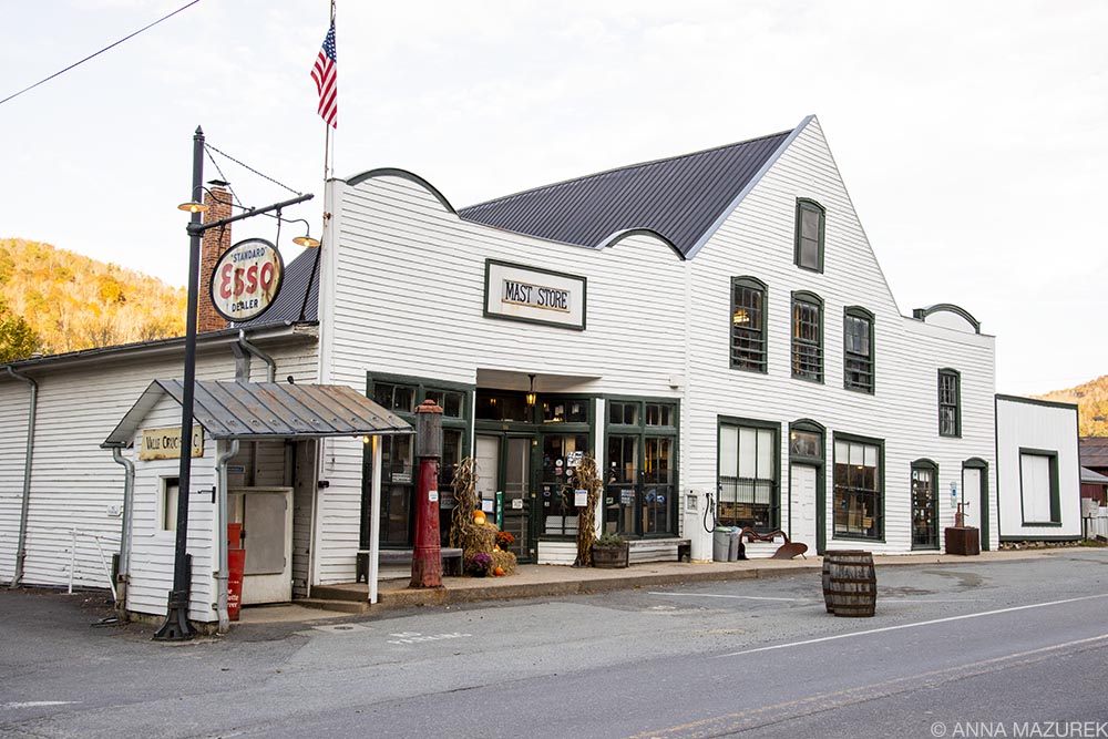
Next, I drove into Boone and had lunch at Booneshine Brewing, which I totally recommend. It’s by a lovely little park with a walking trail. I was basically killing time in Boone so I could go do a sunset shoot at the original Mast General Store in Valle Crucis built in 1883. The light wasn’t as good as I’d hoped so the building was a bit in the shadows so I’d recommend going before sunset to photograph it. It was still a lovely area with lots of cool barns nearby. The store itself was really interesting. The annex is about half a mile down the road.
The hotels in Boone were very pricey so I stayed in Wilkesboro, NC for the night for about half the price.
Day 5: Blue Ridge Parkway – Blowing Rock to Asheville
(Milepost 293-382)
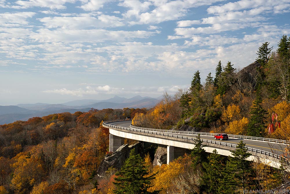
I got up at 5:50 a.m. to drive to the spot where I got my favorite photos of the ENTIRE trip! I made it to Linn Cove Viaduct by 7:30 a.m., which was just after sunrise an excellent time for photography. (The 1,243-foot viaduct is an engineering feat built with 153 segments at 4,100 feet to protect the environment of Grandfather Mountain) The viaduct is best shot in the morning when the light is hitting it. I parked at a small lot in parking area on the left (when heading south toward the viaduct) near mile 303.9. Then, I walked on a path along the edge of the road on the opposite side of guardrail from traffic. There were a handful of people around (mostly photographers like me with tripods) and almost everyone was wearing a mask.
The best spot for photography is directly across the road on top of a few big rocks. There’s a short climb to the top but only room for one person really to shoot at a time. I waited my turn and got a great shot of a red car going around the curves as the sun highlighted the edges of viaduct. (There were two people on the rocks when I arrived so I waited until one left to go get my place in line.) Once the sun came out, I didn’t really need the tripod so I’d advise not bringing one if it’s pretty bright. By 8 a.m, I didn’t need the tripod.
It’s dangerous to stop on the viaduct to take photos so please make sure you park in the lot and walk back along the path. There was a very rude old couple who literally parked in the road (partially blocking it) to climb up the rocks. Then, they had the nerve to try to get in front of me to take a photo. Despite the tight space, they weren’t wearing masks because “they’d left them in the car.” Even in non-COVID times, it’s best that only two people be near the top of the rocks and other people just wait at the bottom for people to come down. (It’s a very short climb.)
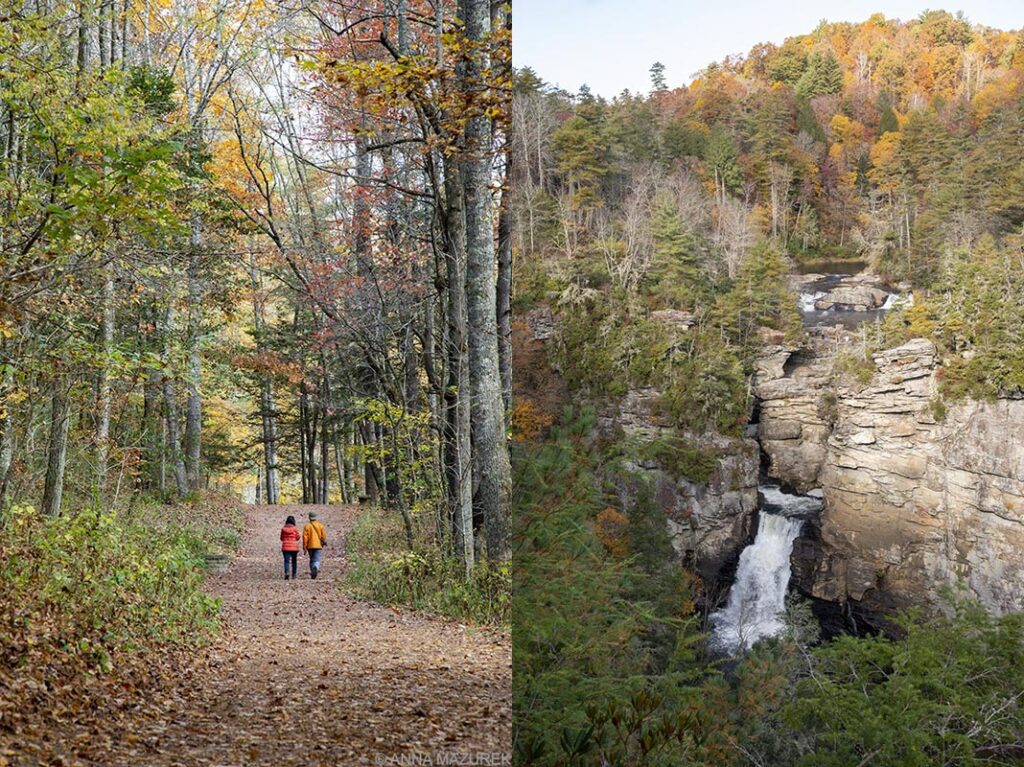
My next stop was Linville Falls, a three-tiered waterfall called the “Grand Canyon of the Southern Appalachians.” The parking lot was only a third full when I arrived around 9:30 a.m. but when I left around 11, people were waiting for parking spaces! It’s one of the most popular spots on the parkway. I hiked to all the viewpoints skipping the closest one to the parking lot that was packed. It was a wide trail so easy to distance from others. Most people had masks they put on when they were near others.
This is a tricky spot to shoot due to the angles of the viewpoints and the deep gorge. Mid-day might be best to get light on the falls and walls of the gorge. A cloudy day is also a good to avoid any harsh shadows or glare.
I stopped at Mount Mitchel next, the highest peak (6,684 feet) in Appalachian Mountains. It’s a few miles off the parkway. When I got to the top, I was shocked by how packed the parking areas was! There’s also a large picnic area near the top that also draws crowds. I took a photo of a sign at the end of the parking lot with the elevation on it but didn’t walk to the main viewpoint because there were over a 100 people! It just didn’t feel safe so I got in my car and left.
The parkway got more and more crowded as I got towards Asheville. Honestly, it was pretty busy from Boone to Asheville, which was the most crowded part. It was also a Friday so that could be part of the reason so many people were out. My initial plan was to drive all the way to the end of the parkway in Cherokee, NC, but my car started to have some problems near Ashville so I headed to my parent’s farm in South Carolina. (Turns out the blower motor went out in my car, which was an inexpensive repair thankfully!) I’ll have to go back and finish the parkway at another time – perhaps mid-week to avoid the crowds.
Travel Safety
This solo road trip was my first trip since March. I went during the week to avoid crowds as much as possible. These places are always busy during the fall, and visitor numbers are still increasing despite the pandemic. I got up at sunrise and tried to be at the most popular spots as early as possible. In my experience, if you get to a place before 9 a.m. then it’s usually not bad at all. (Sunrise was a 7:30 a.m. so I did my best to get to places as close to then as possible. I also didn’t want to be driving on the remote roads too early because wildlife is a concern in the dark so timing was tricky.) Even when I ran a photo trip in Yellowstone a few years ago during peak season, the most famous spots were empty before 9 a.m. and after 6 p.m. I also skipped a lot of places due to the crowds because of COVID fears so I’d like to go back to those another time.
Normally, I would stay with friends or camp during a road trip, but neither feels safe now. The idea of camping and sharing communal bathrooms just felt gross so I stayed in hotels, which wasn’t cheap. Initially, I was looking into renting houses or whole apartments on Airbnb so I could have a space completely to myself. Hotels had a much more flexible cancelation policy, which is why I ultimately went that route. (Since the leaves don’t exactly give advance notice when they are changing, I booked hotels for three weeks straight just to be safe then canceled what I didn’t need.) Hotels were also slightly cheaper ($80-100/night) for a nice hotel while Airbnb’s were over a $100 unless you rented a room in a shared space. One of the ways COVID is changing the way I travel is that I’ll be spending more on nicer accommodation and avoiding shared spaces like hostels, which I used to love for the social component. I’ll book a place based on whether or not I could stand to quarantine there.
I stayed at Hampton Inns for four nights – two nights in Harrisonburg, Va., one night in Hillsville, Va. and Wilkesboro, N.C. I felt really safe in the hotel rooms – they felt very clean, but I still Lysol-bombed the place when I arrived just to be safe! I picked hotels that offered digital keys so I could check-in and unlock my room with my phone, which I recommend everyone do! They required masks in the hotel and I didn’t really see too many people in the common areas. (Both states had mask mandates in public areas.) I took the stairs when I could to avoid people in elevators. There was hand sanitizer by all the elevators. The gyms were either closed or by appointment. (I’m not sure when I’ll ever feel safe in a gym again so I skipped these.) Breakfast was a to-go bag, which I also skipped. I brought my own food for the trip but tried to eat out (to-go only) at local restaurants to help support small businesses. Since ventilation has been a concern, I avoided turning on the heat or air conditioning. Plus, the weather was really nice so I never felt like I needed it. The hotel windows didn’t open. Otherwise, I would have aired out the room.
The least safe I felt the entire trip was on bathroom stops so I tried to pick the least crowded rest areas or gas stations. Again, the Turk Mountain hike didn’t feel safe due to the narrowness of the trail and the amount of people I passed. Otherwise, I felt completely safe on the trip. I kept a mask and hand sanitizer with me at all times as well.
The only thing that bothered me about these hotels was that the smoking area seemed to be right outside the front door so the smoke filled the lobby and stairs by the lobby entrance. It just felt gross to be smelling smoke or walking through smoke that someone without a mask was blowing into the air. (This was an issue in Wilkesboro but an even bigger issue a few weeks later when I had to stay in a hotel last minute while driving back to Texas for a work project. I had to outrun Hurricane Zeta and got stuck in Monroe, Louisiana for the night. I booked another Hampton Inn on my phone when I arrived but picked a terrible one. Over half the guests weren’t wearing masks and the hotel staff was only wearing them half of the time. This hotel was crowded and felt really unsafe. Again, people including the hotel staff were smoking right by the front entrance, which was just gross during a pandemic to have to walk through that smoke. When the hotel sent me a survey, I let them know all these details. )
Please note that COVID rates have doubled across the U.S. since I took this trip. I was planning to take a month-long hiking trip with a friend in the Southwest this winter. We had a very safe trip planned – we were both getting tested before/after, renting entire houses on Airbnb and literally avoiding all people by hiking early or cooking/ordering food to-go. Based on our planning, our biggest risk was gas stations and grocery stores. With the massive increase in rates, ICUs filling up across the country and seven of my family members testing positive with COVID this week (mostly mild cases), my friend and I are planning to cancel our trip.
For more photos of my trip, please check out my Instagram story highlight for my Fall Trip. Email me with any questions.
A Note on Travel Insurance
It’s more important that ever to have travel insurance when you travel. Companies like Safety Wing and World Nomads both cover COVID so please make sure you have proper coverage when you travel. Both companies also include travel in the U.S. usually as long it’s 100 miles from where you live. (Please note I earn a small commission if you book through these links, which helps cover operating costs for this blog.)